


Forgotten Springs, vol.1 – a Tangled Valley and the Ruins of an Old Amphitheater
- Published: February 24, 2017

Photos by Aaron Zaremsky
Text by Dylan Taylor-Lehman
In JG Ballard’s 1974 novel Concrete Island, the protagonist is involved in a car accident on a highway ramp and goes over the edge of the barrier, finding himself in a sort of forgotten wilderness area created where the highways overlap. He is trapped in this strange triangle, and soon finds that a few other people are too.
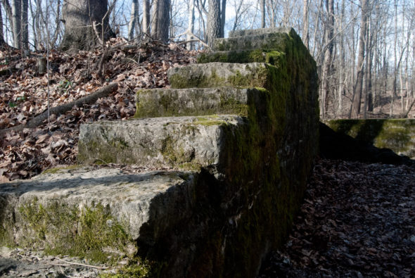
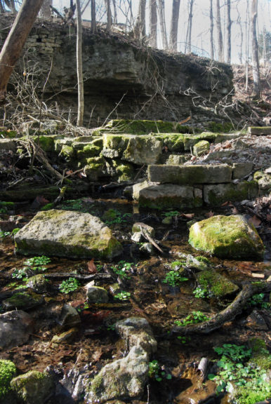
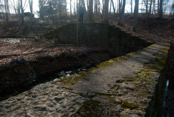
Locally, the triangular valley created by Cemetery Street, the Bryan Center and route 68 gives off a similarly forgotten vibe. While the presence of cars and houses doesn’t put local explorers in quite as dire straits, the preponderance of ruins and tangled underbrush creates a sense of the forlorn in the way that only crumbled human structures can. There are remains of an amphitheater, some walkways and bits of a dam, all of which speak for something that once was but now is not.
In this first entry in an occasional series about the lost corners of Yellow Springs, photographer Aaron Zaremsky and I will post some photos of and reflections on these areas, which are beautiful in their own right and tend to disrupt the human tendency to think about our lives as if we’ll go on forever.
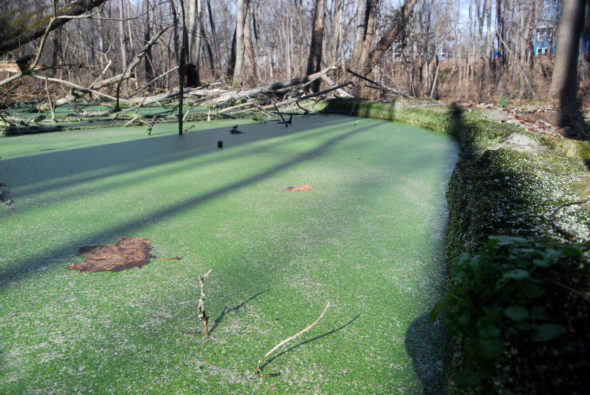
Mosquitoes abound in this valley and stagnant water is covered with primordial slime, and the whole area is overseen by a decapitated tower of some sort. Teenagers everywhere can rejoice that the remains are actually part of what used to be a high school. Too much joy can’t be taken in a school reduced to rubble, however, as the ruins are only those of a few accessory structures and not the school itself. In fact, the Bryan Center used to be the village’s high school, and that building, of course, is still standing.
The origins of the Bryan Center began in 1902, when John Bryan (of the eponymous park) bought the land from a a man who previously operated a home for the elderly. The home for the elderly burned down earlier that year, thanks in part to the local fire department’s inability to connect to the nearest fire hydrant. As if a burned-down old folks’ home didn’t make the area gloomy enough, a murder took place in one of the homes built along the creek in the same valley.
The story goes that a winsome naturalist and autodidact named Denman Duncan caught the eye of one Mrs. Hanes, whose husband worked at a nearby nursery. Mr. Hanes became incensed that his wife marveled at Duncan’s apparently superior knowledge of ferns. “Skunk cabbage is all he’s ever found,” Hanes huffed. Jealously ate at Mr. Hanes, and so one night he crept over to Duncan’s cabin and killed him with a hatchet. Naturally, this untimely death has inspired talks of phantasmagoric sightings in the valley, primarily in the form of a phosphorescent fern that Duncan (and Mrs. Hanes) liked. (As Aaron and I were there in the middle of the afternoon, we did not experience this phenomenon.)
John Bryan ultimately gave the lot to the Village in 1916 and asked that they build a school there. However, Bryan had a few stipulations: the school couldn’t bar from attending anyone based on race, there was to be no basement in the school (why he made this request I don’t know) and no religion could be taught in the school building. The latter concern was particularly important to Bryan, as he made the same prohibition in the park bearing his name.
Bryan’s antipathy toward religion was exacerbated by a tiff he had with Antioch College. Bryan fancied himself an author and at one point self-published a book of fables. When he tried to get the book into the library of the College, it was rejected because it apparently didn’t have any religious value. Bryan was a staunch agnostic and found the rejection galling, and so in order to spite the college, he began buying land adjacent to it and vowed to put it out of business. While he didn’t succeed in driving away the college, he willed his land to the state for use as a park, provided that no religious services could ever take place on its grounds. (The long arm of the Lord ultimately prevailed, however, when courts ruled that religious beliefs couldn’t be banned from public land.)
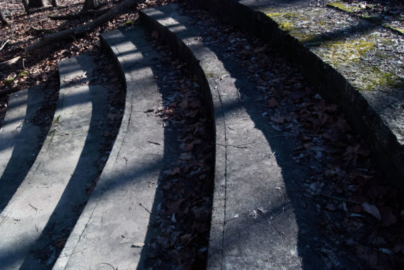
The school was built in 1928, and a grant from the Works Progress Administration was used to construct an amphitheater, a stone walkway, tennis courts and many of the other accouterments whose remains can be explored today. The school was moved to its present location in 1963, and the building was renovated to become the community center and police station that we know today.
Regardless of the origins and the history that has characterized the land, the eternal natural processes are what ultimately have dominion in this valley. Visitors can be subsumed by the tranquility of the moss and the trees, just like remains of previous human endeavor.
(Thanks to yshistory.org for much of this background.)
7 Responses to “Forgotten Springs, vol.1 – a Tangled Valley and the Ruins of an Old Amphitheater”
The Yellow Springs News encourages respectful discussion of this article.
You must login to post a comment.
Don't have a login? Register for a free YSNews.com account.


When I was in school (class of ‘71), we called the area “the ravine”. In biology we grabbed water samples there to find “planaria”. The lesson was to show they would grow two heads after splitting it in two.
Great info! For such a small town my beloved hometown has such a rich history.
This area is one of my favorite hidden gems right in the heart of downtown where I spent many summers with friends playing amongst Yellow Springs creek, the amphitheater, and the culvert. We did actually have a makeshift play there in the late 70s early 80s, I can’t remember the name of it if anyone reading remembers any actual events there.
I would love to see it used again if there aren’t any safety hazards and erect another bridge over to Cementary St. Once large events resume it would be beneficial for walking about town.
I visited this area recently reminiscing myself and envisioned carving a Yellow Springs sign over the culvert, who wants to invest in that?
In my youth, I spent a lot of time exploring this area with friends including Laurens Vernot. If I remember the stories correctly, John Bryan gave the land to the town requiring that the school be single story building because his son had been injured (killed??) falling down the stairway in a multi-story school. Bryan High School was designed to be single story on one side to meet this restriction, However the thought of a single story high school was too radical for 1928 so the back side of the building was two stories as was conventional at the time. Using 1960’s terminology, the school would be classified as ‘split level’ with the front entrance between the floors. It therefore not considered to be a two story building.
The High School Football Field was on the south side of Cemetery Street. There were carefully planned paths including a bridge across the creek to get from the school to the athletic field. In the late 1960’s and early 1970’s, John Hart brought the circus to town every year at the old athletic field before ultimately bringing it to the current high school. Does anybody remember the year the tent main pole collapsed in a downpour?
John Bryan’s request that the park that carried his name not be available for religious groups was honored at least until the mid 1970’s in spirit at least. Religious groups were banned from reserving shelters, Orton swimming pool, and the day lodge. This was easily and commonly circumvented by having an individual reserve the space without stating purpose.
Interestingly, John Bryan Park became Ohio’s first state park in 1949. The state had accepted the gift of Riverside Farm in 1918 but really had no idea what to do with it. In 1925 it became a ‘Forest Park’ as the state began evolving the purpose for the land. One of John Bryan’s request was that the land be used for forestry and education which led to land that is now in Glen Helen being leased to the School Forest organization for $1 per year. In 1949 when John Bryan Park was established by the Ohio Department of Natural Resources I believe there was some land swapping between Glen Helen and John Bryan Park along John Bryan Park Road. Historians please fact check me on this point.
I will close by pointing out that when Walt McCaslin was stabbed to death by his son in 1981, the Yellow Springs News asked its readers if anyone could remember when the last murder had occurred in the village. The reply by historians including Julie Overton was Denman Duncan’s murder in 1915. That makes sixty six years between murders in the town. How many murders have there been in the 41 years since McCaslin? I don’t know the number, but I can count 5 just from memory!
Very interesting historic information. Learned of page after learning that Richie Furay was born In Yellow Springs!! So cool! The park and the free concert (June, 1971 @ Antioch College) featuring Van Morrisson is a very great memory of my friends and myself! AND…the pictures are places that we once lazily strolled…
Me and my childhood friends spent many summer afternoons exploring this triangular valley and fishing under the culvert that runs under route 68. I was always fascinated by the ruins and was saddened to find the whole area overgrown with, and the stone features being uprooted by, honeysuckle when I was last there a few years ago. The pictures show someone has put in a lot of work to clear the area of invasive plants and expose the interesting stone work once again for our enjoyment. Many thanks for this great article, for the photos, and to those who did that backbreaking work.
Police station and courts were on Dayton st before they moved to the Bryan center in the late 80s early 90s
Fascinating & well written! Great photos too! Thank you both for this 1st installment, looking forward to more! And I really didn’t know much about John Bryan, wow!