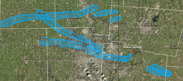
On Tuesday, the National Weather Service’s Wilmington office released an image showing the paths of possible tornadoes from the previous night’s storm. Yellow Springs was mercifully spared a tornado that went through Beavercreek as an EF3 with estimated maximum winds speeds of 135 to 140 miles per hour. That storm cell petered out as it reached town but still came with damaging hail. (Photo courtesy of NWS)
A tornadic near-miss Monday
- Published: June 6, 2019
Around 11 p.m. on Monday, May 27, Yellow Springs residents were roused from their beds by the whine of tornado sirens as the National Weather Service issued a tornado emergency for Yellow Springs. Residents huddled in basements and interior rooms as the village was pelted with hail and rocked by wind, rain and thunder, but was otherwise left relatively unscathed by at least one EF3 tornado that touched down in the Miami Valley.
The National Weather Service, or NWS, in Wilmington issued the tornado emergency at 10:58 p.m. — a tornado emergency is an enhanced tornado warning that indicates a high likelihood of severe damage and fatalities in an area where a tornado has been spotted. Another tornado warning for the area was issued around 11:45 p.m., indicating a second tornado. On Tuesday, surveyors for the National Weather Service confirmed that Trotwood, Beavercreek and Celina had been slammed by tornados ranking 3 on the Enhanced Fujita, or EF, scale, with winds up to 140 miles per hour. The NWS also later confirmed a total of 16 tornados in Ohio during the storm.
The storms left devastating destruction in their wake in the affected towns, with major structural damage inflicted on homes and businesses. More than 50,000 Dayton Power and Light customers were without power by Tuesday afternoon, and Greene and Montgomery counties both declared a state of emergency.
Though the paths of tornadoes and their wind speeds are typically only approximated by the damage the storms leave, the NWS has published maps showing circulations that potentially produced tornadoes in Ohio. These maps trace several distinct paths originating in Darke and Preble counties, traveling southwest through Brookville, Trotwood and Englewood, continuing through Riverside and Beavercreek, heading toward Wilberforce, and finally angling back up toward Yellow Springs — before mercifully petering out.
Local damage
Around 12:45 a.m., the tornado warning was lifted for Yellow Springs, and residents began to emerge from their homes, intending to assess the damage — most of which seemed to have been caused by hail.
“We are in the Vale at the end of Hyde Road, and had hail the size of golf balls, causing damage to both cars,” said Sarah Badger, one of many who reported damage to automobiles by the hailstorm.
“The devil was the hail on the south side [of town],” agreed Francis Jennings. “It blew out all eight of my sun tubes, caused extensive damage to my roof and dented the heck out of my poor truck.”
Some flooding also plagued parts of the village — the NWS issued a flash flood warning around midnight. Villagers with rain gauges reported anywhere from two to just over four inches of rain. Linda Rudawski posted photos on Facebook of her Herman Street basement, in which several inches of water had pooled.
“The rain water runs down Herman like a river,” said Rudawski. “The run-off issue is bad.”
Chief Colin Altman said Miami Township Fire-Rescue only responded to one call related to the storm — a broken utility pole was blocking a road in the township.
“We haven’t really seen any structural damage — just some lines down, some trees,” said Altman. “We really lucked out.”
Many folks in town reported minimal debris, though Caroline Mullin said her family found “lots of branches and trees down” at their farm north of John Bryan State Park.
“[I’m] unsure if it was just wind,” she said.
Outside of plant matter, residents reported finding siding, insulation and other debris that couldn’t be placed locally, and which had most likely been blown in from areas that suffered more extensive damage. Carla Purvis was housesitting on Southview Drive during the storm, and when she went out to survey the backyard after the sun rose, she found mail littering the grass — all of it addressed to a Roger T. Stewart of Brookville, more than 30 miles away, near where the storm started.
“It was just the weirdest thing — that mail traveled all that way,” she said.
Siren concerns
Even though the storm turned out to be milder than the tornado emergency suggested for Yellow Springs, some residents were concerned about the village’s tornado sirens, and whether or not they’ll be reliable for future storms.
“I never heard one siren,” said Jayne Richeson, who lives on the south end of town, near Dollar General. “If I hadn’t had my cell phone, I never would have known. I wasn’t sure if it was because the hail and storm were so loud or if they just didn’t go off.”
Stephanie McClean, who lives on Omar Circle, did hear the sirens — “faintly, through closed windows and door … but we did hear it,” she said.
Other residents were concerned with how to know when the danger has passed.
“I wish the Village had an ‘all-clear’ signal,” said Peggy Koebernick.
The Village maintains three sirens, with one at Beatty Hughes Park in Kieth’s Alley, a second at Allen and Livermore streets and a third at Bill Duncan Park on Dayton Street. Village Manager Patti Bates said that the latter two were rehabbed in 2017, and the former is scheduled to be rehabbed next year. The sirens are tested on the first Monday of each month at noon.
“Village team members are standing nearby [during the tests] to ensure that they are functioning properly,” said Bates. “If they are not, they are promptly repaired.”
If villagers are concerned that a nearby siren is not working properly, Bates said they should get in touch with Village Public Works Director Johnnie Burns at 767-8649.
Chief Altman said that the purpose of tornado sirens is to alert those outside to get indoors and to shelter as quickly as possible, and that those indoors should not rely on the sirens alone for warnings or for information on when the threat is past.
“The logistics and money required to have [sirens] audible inside every residence is prohibitive,” he said. “[Miami Township Fire-Rescue] urges everyone to sign up for Hyper Reach from the Village and County and to download a free app that can provide instantaneous weather alerts — I use one from FEMA.”
Altman said that once a tornado watch is posted, people should plan to stay alert for around eight hours, and that when a warning is issued, it usually lasts at least 45 minutes.
“By national standards, no ‘all-clear’ is given, as it can lead to confusion,” said Altman.
On the night of the storm, it was YSPD Dispatcher Ruth Peterson’s job to sound the siren once the warning came in from the National Weather Service. Like Altman, she stressed the importance of staying tuned to local media, phone apps or National Oceanic and Atmospheric Administration (NOAA) Weather Radio during a storm. She also said that any folks who are outside when the sirens go off, or those who don’t have an adequate place to hunker down, are urged to come to the Bryan Center, which is always open as a tornado shelter.
“We had around 40 people here during the storm [on Monday night],” she said. “And four dogs. No cats.”
For more information on how to prepare for a tornado, and what to do when one is eminent, visit http://www.weather.gov/safety/tornado.


Comments are closed for this article.