


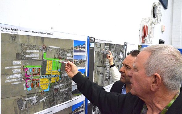
Earlier this year, on Jan. 23, the Village gathered public feedback from around 150 community members on land use concepts as part of the Comprehensive Land Use Plan process now underway. At right, Jose Castrejon, a landscape architect and project consultant, discussed a possible layout for housing on the Village-owned Glass Farm with a nearby property owner. (Photo by Megan Bachman)
Village Comprehensive Land Use Plan— Parking, Glass Farm changes
- Published: October 21, 2020

A design for expanding parking around Mills Lawn was removed from the Village’s draft comprehensive land use plan during Village Council’s Oct. 5 virtual meeting.
Council voted to remove the concept after receiving a petition signed by 32 neighbors and hearing critical comments at its meeting.
More parking in the area is unnecessary, would impede the “openness” of the Mills Lawn green space and was potentially dangerous to pedestrians and school kids, neighbors argued. They also worried that it could signal to developers that the area was transitioning to a commercial area.


“This is changing the residential character of our neighborhood,” Julie Ford, of Phillips Street, said of the plan.
Pulling the parking concept was one of a handful changes Council made during the first reading of an ordinance adopting the new comprehensive plan, a vision for local land use through 2030.
In other changes to the plan, under development for the last year-and-a-half, Council voted to amend the anticipated zoning for a possible future Glass Farm housing development from high-density residential to a combination of medium-density residential and “conservation development.” A proposal to slate the entire Glass Farm as green space did not move forward.
Council also voted on, but did not pass, a proposal to change the future land use for Mills Lawn if the elementary school ever closed there should a new facility be built elsewhere. That proposed change would have seen the eastern one-fourth of the property be transitioned to commercial use and the western three-fourths become open space. Currently, the zoning for the entire parcel is set to become high-density residential.
And in a final change, Council added a plan to annex three Village-owned properties currently outside of village limits into the municipality when possible. Those properties are the Sutton Farm on Ohio 343, Ellis Pond on Polecat Road and the Village water plant on Jacoby Road.
Council will vote on the second and final reading of the plan at its next meeting, Oct. 19.
Addressing public comments and what he said was a “fundamental misunderstanding” of how a comprehensive plan is used, Council President Brian Housh said the plan’s concepts are not “automatically implemented” but may be used when an opportunity to do so arises.
“A comprehensive plan does not mean anything will happen,” Housh said.
Council Member Kevin Stokes added that if Council was to enact anything in the plan they would seek public input, because “the public deserves that.”
But to residents worried specifically about the Elm Street/Phillips Street parking expansion, those assurances were not enough. They wanted to see the concept pulled from the plan entirely so that it wouldn’t get implemented later.
“I get what you’re saying that this is not etched in stone,” said Elm Street resident Mike Slaughter. “But anything documented … you can fall back on and can get implemented quickly.”
Parking plan challenged
Much of the discussion during the comprehensive plan’s first reading centered on a single parking concept for Elm Street and Phillips Street near downtown.
At present, gravel parallel parking is available on both streets along the Mills Lawn property. The new plan calls for 38 paved, angled-in spaces on Elm Street, and 33 on Phillips Street.
That concept was concerning to some neighbors, who in a petition challenged the need for parking, worried that the parking would “impede the openness” of the green space and endanger bicyclists due to drivers backing out into traffic, among other concerns.
Addressing the larger issues signified by the parking expansion, Parker Buckley, who lives on Phillips Street, said at the meeting that the plan “raises all kinds of flags,” that changes are being eyed for what he called a historic, residential neighborhood.
“It seems the ground is being plowed for this to gradually become a commercial area, a part of downtown,” he said.
The parking plan raised concerns for Dayton Street resident Maria Booth for similar reasons. She worries that the plan prioritizes visitors ahead of residents.
“We as a village need to think about the needs of the community and the residents who live in the neighborhoods versus responding to the needs of potential tourists or commerce,” she said.
Asked how the parking expansion was added to the plan, Housh said that it arose during small group meetings with “stakeholders,” including Yellow Springs Schools and Antioch College, who are exploring the possible siting of a new K–12 school on the Antioch campus. They gave feedback, he said, about “how the use of [Mills Lawn] would change.”
“We didn’t just do that on our own,” Housh said.
Village Manager Josué Salmerón added that the steering committee that drove the process to draft a new comprehensive land use plan identified “key areas” to explore and parking was among them. A documented need for more parking downtown dates back to at least 1972, he added.
“Parking has been an issue in the community but the community doesn’t have any interest in putting anything online,” Salmerón said. “There is no easy fix to this.”
Salmerón added that the benefit of the Elm/Phillips Street plan is that it “doesn’t take any property offline,” as it would be just a reconfiguration of existing spaces.
In the end, Council Member Laura Curliss moved that the parking study for Elm/Phillips streets be removed from the plan. The motion passed in a 4–1 vote, with Council members Curliss, Housh, Lisa Kreeger and Kevin Stokes voting in favor and Marianne MacQueen dissenting.
Other parking concepts in the comprehensive plan are to add paved, angled parking on a portion of Beatty Hughes Park that fronts Corry Street and to add paved parallel parking along Corry Street adjacent to the bike path. Those concepts remain in the plan.
The future of Mills Lawn
Broader issues surrounding the future of the Mills Lawn property arose during the discussion. In a memo to Council, Curliss laid out a vision for the property as mostly green space. Curliss clarified that the change does not mean “it ever has to stop being a school,” since that is a grandfathered use of the property.
“The future vision would be to keep that green space, except for the footprint of Mills Lawn,” Curliss said of her proposal.
During the meeting, Curliss moved that the western three-fourths of the Mills Lawn property be recategorized as parks and open space and the eastern one-fourth (corresponding to the current footprint of the Mills Lawn school building) be changed to the central business district.
Kreeger seconded the motion, and said making the change would be “signaling the importance of green space property on Mills Lawn rather than that becoming a development.”
Aaron Sorrell, the Village’s consultant on the comprehensive plan, expressed some caution about the change, which he said is akin to “casting the future on that property.”
“You are not rezoning, but it will lead the public and the future developer toward what the future use is,” Sorrell said.
Sorrell said that the steering committee “went back and forth on this property,” but that, in the end, they decided they didn’t want to “throw a wrench in whatever the school is doing.”
“Because of the uncertainty of where the school district was going, we made a conservative move to leave it as public use,” he said, with the underlying use to remain residential.
Asked by a neighbor for clarification on other stakeholders involved in discussions around the property, Sorrell added “the business community, high school students, realtors, developers.” He added that any change outside of high density residential for the property would require a “significant public effort.”
Mentioned briefly at the meeting was a 2019 school district analysis of the residential potential of the western portion of the property, about 4.8 acres, on which they determined could be built 30 to 62 housing units.
From the floor, resident Matt Kirk said that since an initial proposal from the school district to build a new K–12 facility on Mills Lawn was widely panned, the community has already made it clear that it doesn’t want development on Mills Lawn.
“I would caution against putting and codifying anything in the plan that would allude to the erosion of Mills Lawn as anything other than a community green space or public school,” Kirk said.
On that issue, Housh said any change of use at the property was too far in the future, with too many variables, to make a definitive decision.
The motion failed after Curliss and Kreeger were the sole yes votes; Housh, MacQueen and Stokes voted against it.
Glass Farm development?
Pivoting to another property, Curliss made a plea for the 42-acre Village-owned Glass Farm to be identified as a conservation area. In the current version of the plan, 25 acres of the farm are planned for a combination of high-, medium- and low-density residential development.
Curliss suggested that the property would be expensive to develop because of the “hydric,” or water saturated, nature of its soils.
“This property has more value to the community as a wetland and conservation area,” she argued.
After her motion failed to garner a second, Curliss proposed removing the “detailed study,” which lays out more than 100 single-family homes and four multi-family apartment buildings on the Glass Farm. That failed on a 1–4 voice vote, with Curliss the only Council member voting in favor. A final motion from Curliss to change the plan to a “conservation development” did not get seconded.
MacQueen rebutted Curliss’ arguments, saying that only two of the five areas of the property have hydric soils and that those areas of the property do not have the flora and fauna to be considered a wetland.
“Glass Farm is not a wetlands,” MacQueen added. “Laura Curliss has stated this a number of times but stating it does not make it more accurate.”
Further, MacQueen countered Curliss’ suggestion that any developer would approach the Village for financial assistance because of the likely high cost of developing the site.
“If the Glass Farm would be costly to develop, it probably would not be developed,” she said. “The village has never stated it would be the developer.”
Kreeger then moved that the planned development at the Glass Farm be changed to a mix of “conservation development” and medium-density residential “to be determined based upon a further evaluation of soil and village needs.”
That motion passed 3–2, with Kreeger, Housh and Stokes voting yes and Curliss and MacQueen voting no.
Annexation of Village properties
A final amendment to the comprehensive land use plan involved the future annexation of Village-owned properties outside of municipal limits. After Miami Township recently refused the Village a building permit to construct a storage shed at the Sutton Farm, the Village has worried about its ability to “protect municipal assets” at the sites, Salmerón explained at the meeting.
The Sutton Farm, the water plant on Jacoby Road and Ellis Pond were named as three properties added to the comprehensive land use plan as areas that should be annexed when possible.
Asked by the News if this would contribute to development pressure in those areas, Village Solicitor Breanne Parcels said “if anything, it would be negative annexation pressure,” as the Village wouldn’t develop those areas. At present, the Village’s policy is to not extend utilities beyond the urban service boundary, and only the Sutton Farm lies within the town’s urban service boundary.
Since at least two of the properties do not border the Village, their annexation is not likely to occur anytime soon, Village officials added.
The full plan can be viewed at http://www.sustainableyellowsprings.com.
In other Council business—
• Council passed the first reading of several ordinances amending planning and zoning code regulations. The changes would require uncommon lot configurations be reviewed by Planning Commission, setbacks from Village power lines, stormwater management plans, alleys configured to Village standards and sidewalks and underground power lines in new developments, among other requirements.
In explaining the proposed amendments, Swinger said that because climate change is leading to more high-rain events and there is more infill development in town, stricter stormwater guidelines are needed to slow down rainwater before it flows into municipal sewers.
• Salmerón reported the Village has received more federal money for coronavirus relief. With the additional $150,000, the Village’s total is now up to $330,000. In April, the Village projected a loss of $320,000 in tax revenues and other economic impacts from the pandemic.
• Matt Hoying and Ryan Lefeld from Choice One Engineering presented their recent study of the Village’s stormwater system. The conclusion is that the village’s stormwater system is deficient, with aging pipes that are often too small for the area they drain. In addition, with more frequent high-intensity rainfall events, all communities, not just Yellow Springs, are struggling to manage stormwater.
“What probably won’t come as a surprise to you, is that many of those areas [we studied] had stormwater runoff deficiencies,” Hoying told Council.
Hoying said that upgrades should be targeted to priority areas and that the Village could consider a new stormwater utility so residents pay a monthly fee for. However, it’s “not something that residents easily take kindly,” he said
As part of the study, the engineers also came up with solutions to three areas previously identified by the Village as problematic: 350 Orton Road, 1360/1370 Rice Road and the intersection of Dayton Street and King Street.
• A preliminary study on the Village’s electric utility concluded that the Village was “reaching the limitations of serving the electric load of the Village effectively.” It recommended a series of upgrades, including rebuilt main distribution circuits and improvements to the switching station, at an estimated cost of $4.3 million.
Council’s next regular meeting was Monday, Oct. 19, on Zoom.
The Yellow Springs News encourages respectful discussion of this article.
You must login to post a comment.
Don't have a login? Register for a free YSNews.com account.


No comments yet for this article.