


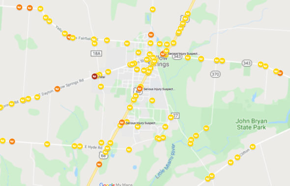
Traffic accidents in which an injury was possible or occurred in the Yellow Springs area, 2014–2019 (Google map created with ODOT data)
MAP: Traffic crashes in Yellow Springs
- Published: November 20, 2019

Traffic safety and congestion are on the minds of villagers as a three-week temporary transportation project in downtown Yellow Springs came to an end last week.
Over the next few weeks, the News will be taking a closer look at the rationale behind the recent traffic trial and the strategies outlined in the Village’s Active Transportation Plan. Read last week’s article, “Origins of the traffic trial” and pick up the Nov. 21 issue of the News for “YS Schools welcome traffic experiment” The Active Transportation plan is available here.
Village leaders are also now collecting feedback on the temporary transportation project. Their online survey ends Nov. 23.
Using data obtained from the Ohio Department of Transportation, the News created an interactive map showing where most vehicle accidents occur in and around the village (link is below).
From January 2014–October 2019 there were 303 crashes in Yellow Springs and 371 crashes in Miami Township. In total, in the two areas there were:
- 546 crashes with property damage only (243 in YS)
- 55 crashes with minor injuries possible (27 in YS)
- 93 crashes with minor injuries (21 in YS)
- 13 crashes with serious injuries suspected (3 in YS)
- 3 crashes with fatalities (1 in YS)
The breakdown of traffic crashes by road in the village and township is as follows:
| Road | # crashes |
| US-68/Xenia Avenue | 207 |
| Dayton-Yellow Springs Road/Dayton Street | 83 |
| Clifton Road | 62 |
| Ohio 343 | 47 |
| Hyde Road | 36 |
| Ohio 72 | 31 |
| Yellow Springs-Fairfield Road | 25 |
| Corry Street | 18 |
| Wilberforce-Clifton Road | 17 |
| Enon Road | 12 |
| Grinnell Road | 12 |
| Walnut Street | 12 |
| High Street | 9 |
| All other roadways | 111 |
If the map doesn’t display below, CLICK HERE TO VIEW.
Map instructions:
- To view more information on a crash, click on the crash icon, copy the Document Number, and paste the Document Number at the Ohio Crash Retrieval website at the Department of Public Safety: https://services.dps.ohio.gov/CrashOnline/CrashRetrieval
- Note that crashes with Property Damage Only are not shown in the current version of the map. You can check the boxes for Property Damage Only crashes YS and Miami Township by clicking on the icon at the top left hand corner of the page to bring up the menu.
One Response to “MAP: Traffic crashes in Yellow Springs”
The Yellow Springs News encourages respectful discussion of this article.
You must login to post a comment.
Don't have a login? Register for a free YSNews.com account.


On Xenia Ave. Turning left on Corry Street passing post office is very dangerous. I believe a left turn signal could help. Just a suggestion